I traveled from west McKinney to the northernmost section of the Preston Ridge Trail today (around 12.5 miles), but I had to go back before a storm hit. Once you reach the Preston Ridge Trail you have a ton of easy traveling options throughout Plano and nearby Richardson. Here's the full route at mapmyride.com, and here's the return route which is (purposely) slightly different.

I avoided going into the road as much as possible, preferring trails and sidewalks. There was only one place where I really had to go into the road, from McKinney to Frisco for about a minute or two. Whoever plans the trails in McKinney and Frisco should really have lunch together and figure out how to join their separate trails together.
Here's an overview of the route. I travel south on S. Stonebrige Drive, and head down to either Eldorado Parkway or Custer Rd to Frisco. Once in Frisco, you head down Eldorado until you hit Independence, then head south and work your way to Coit Rd. Once on Coit it's easy to pass under the Tollway and head on Ridgeview Drive to the trail entrance. This should take approx. 40-60 minutes.
My trip starts on a small public trail behind a school, which I found on Google Earth.
From here I can easily get to S. Stonebridge Dr., which has several very nice tunnels that allow you to avoid crossing the street above.
Unfortunately, these tunnels are sometimes loaded with ultra slippery "Texas Trail Mud" and water after storms:
The trail passes right by the Bella Donna Chapel:
And is elevated so you get a great view of the lake and surroundings:
The tunnel underneath S. Stonebridge Dr. and Virginia Pkwy:
From here I head south on the trail along Stonebridge:
Pedestrian crossing at Stonebridge and Eldorado. From here you can continue on the trail south on Stonebridge, or turn onto Eldorado and head into Frisco (on the road, unfortunately, but it's a short hop into Frisco and back on the trails/sidewalks).
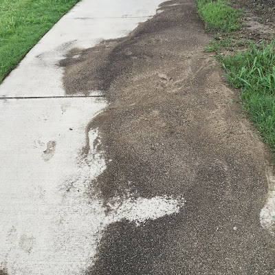
Nearby I ran into a perfect example of the type of ultra-slippery and sticky silt/dirt that finds its way onto the trail. Front wheel drive hub motors are useless in this stuff:
The end of the trail near the Methodist McKinney Hospital, but Frisco is in sight! To get into Frisco from McKinney here you either go into the road, or mountain bike through a field.
I decided to continue southwest on Stonebridge, where I saw some horses in the distance. They were most likely from the nearby Storybook Ranch horse sanctuary:
If you continue down Stonebridge you'll wind up at the intersection of S Stonebridge Dr and Custer Rd:
From here you head north to Eldorado, where you leave McKinney and enter Frisco:
Frisco likes to build its sidewalks very straight, which is awesome. Here's the view down Eldorado, coming up on Independence Pkwy:
Near the intersection of Eldorado and Independence there's a tunnel with a nearby stream:
My ebike, carrying around 900 watt hours of A123 LiFePo4 batteries. This is much more than I usually bring with me:
Cool flowers on the side of the trail on Independence Pkwy:
Here's Independence High School in Frisco:
The trail along Independence going south needs some love:
The intersection at Independence and Main St. is a nightmare of construction. All this construction actually works in your favor somewhat, because it constrains and slows down the traffic. Just cross it like a pedestrian would normally.
Continuing along Independence, on the other side now:
Crossing over West Rowlett Creek:
From here, I wind my way through a subdivision to Rolater and then Coit Rd., where I had south to the tollway. Along the way on Coit you'll pass Frisco Centennial High School:
After going down Coit you'll find your way to the tollway. Crossing under is pretty easy:
Once you cross under you're in Plano, and almost to the trail entrance. Just head down Coit, take Ridgeview Dr (an official Plano bicycle route) east, and you're there:


No comments:
Post a Comment